Albert Water Management Zone

.jpg)
REGIONAL MANAGER
Dr. Guma Brian
DEPARTMENT
Water Resource Planning and RegulationDistricts Covered (6)
INTRODUCTION
The Albert Water Management Zone covers about 61,000 km² in western Uganda, representing nearly a quarter of the country’s land area and spanning 66 districts. It contains major lakes (Albert, Edward and George), key rivers (including Mpanga, Kafu, Nyamwamba and Semliki), and extensive wetlands that sustain livelihoods and ecosystems. Although the zone has abundant surface and groundwater resources, climate change, rapid population growth and rising water demand are driving increasing water stress.
Prolonged droughts affect the cattle corridor districts, while recurrent flooding in the Rwenzori catchments causes loss of life, infrastructure damage and land degradation. The zone also hosts Uganda’s petroleum developments in the Albertine Graben, led by TotalEnergies and China National Offshore Oil Corporation, which present additional risks of water pollution and competition for water resources. These combined pressures underscore the need for strengthened catchment-based planning, climate-resilient investments and integrated multi-sectoral action. Below is a map showing the delineation of the Albert Water Management Zone.
KEY ACHIEVEMENTS TO DATE
1. Catchment Planning & Governance
A total of 10 Catchment Management Plans (CMPs) have been developed for Kiiha, Nkusi, Muzizi, Mitano, Nyamwamba, Mpanga, Ruhezamyenda, Semliki, Nyamugasani and Kafu catchments under in the Albert Water Management Zone. These CMPs now serve as the primary instruments guiding integrated water resources planning, ecosystem conservation, climate adaptation and coordinated stakeholder action at catchment and local government levels.
2. Catchment Restoration & Infrastructure Development
To address land degradation, water insecurity and climate risks, 318.1 hectares of soil and water conservation structures have been constructed in the Mpanga, Ruhezamyenda and Nyamwamba catchments, significantly reducing runoff, erosion and sedimentation into rivers and wetlands. In parallel, 70 small water harvesting structures have been constructed to enhance household and livestock water security, particularly in drought-prone areas.
Forest, wetland and riverbank restoration has been scaled up, with 210 hectares of degraded forest restored and 120 hectares of wetlands demarcated and rehabilitated to restore ecosystem functions, biodiversity and water regulation services. In addition, 80 km of severely degraded riverbanks in the Mpanga and Nyamwamba catchments have been formally demarcated and stabilised using concrete pillars and live planting, protecting critical buffer zones and reducing flood and erosion risks.
3. Water Resources Monitoring & Regulation
The zone currently operates 63 water resources monitoring stations, comprising 45 groundwater stations and 18 surface water stations, enabling continuous tracking of hydrological trends and climate variability. A regional water quality laboratory is fully operational and analyses over 10,000 water samples annually, strengthening pollution control and regulatory enforcement.
In support of sustainable water allocation, 350 abstraction and waste discharge permits are actively monitored for compliance. Additionally, 200 metres of the River Nyamwamba buffer zone has been restored and secured to protect water quality and reduce flood-related risks.
4. Community Livelihoods & Income Generation
To address the link between poverty and environmental degradation, 500 households across the Mpanga, Nyamwamba, Kiiha and Ruhezamyenda catchments have been supported with alternative income-generating activities (IGAs). These include 200 households in apiary (beekeeping), 100 in energy-saving cookstoves, 100 in aquaculture, and 100 in fruit growing. This support, funded through the Government of Uganda. This is already improving household incomes while reducing pressure on wetlands, riverbanks and forests.
Under the Conrad N. Hilton Foundation, the Albert Water Management Zone obtained a grant to implement Watershed Management and Nature-based Water Conservation Activities in Mpanga catchment. Through the grant, collaboration with district local governments and communities has been strengthened, achieving effective wetland demarcation of 300 hectares with pillars, reafforestation of 100 hectares of degraded communal public land, and high community participation and continuous sensitisation. Capacity building in restoration planning and sustainable farming has been carried out at district, subcounty, and parish levels, alongside the establishment of demonstration hubs for high-value crops, including coffee and cocoa. Biodiversity recovery has been observed along restored riverbanks. A telemetric hydrological station and an automated weather station were also installed to improve real-time water and climate data for long-term planning and disaster preparedness.
PRIORITY GAPS REQUIRING INVESTMENT & ACTION
Catchment Planning. Despite the progress made, 17 sub-catchments still lack CMPs, while five existing CMPs are outdated and require urgent updating to reflect climate change realities, population growth and emerging development pressures.
Catchment Restoration & Infrastructure. Significant restoration needs remain, including 3,310.9 hectares of additional soil and water conservation works, 800 new water harvesting structures, 8,080 hectares of degraded forests, and 8,190 hectares of degraded wetlands. Furthermore, 235 km of riverbanks require rehabilitation, and 830 km still need formal demarcation with concrete pillars to protect buffer zones and reduce flood and erosion risks.
Community Livelihoods. While the original target stood at 5,000 households, only 500 households have so far been reached, leaving 4,500 households still in need of livelihood support. Continued population growth and unemployment are driving wetland encroachment, riverbank degradation and overdependence on biomass energy, further weakening ecosystem resilience.
IMPACT FOCUS
Current interventions within the AWMZ are contributing to improved water availability and quality, enhanced climate change resilience, reduced environmental degradation, increased household incomes and food security, and strengthened community participation in water resources management.
WAY FORWARD
The Albert Water Management Zone is prioritising large-scale expansion of catchment planning, accelerated ecosystem restoration, strengthened water resources monitoring and enforcement, and scaling up of community-based livelihood programmes, alongside deeper public–private sector and development partner collaboration. Sustained financing, laboratory and monitoring equipment investment, and continuous community engagement remain critical to closing the outstanding implementation gaps and securing long-term water and environmental security.
Photo Gallery
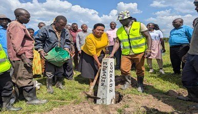
Kamwenge district chairperson & LC5 chairperson launching the planting pillars in Mpanga catchment (funded by the Conrad N. Hilton Foundation)
A Surface water monitoring station installed in Kitagwenda District, Mpanga catchment (funded by the Conrad N. Hilton Foundation)
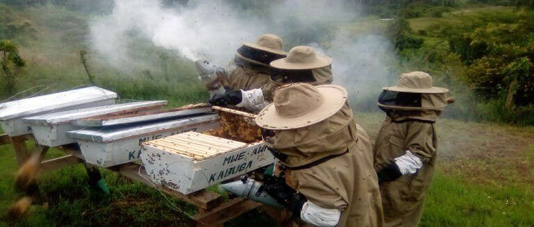
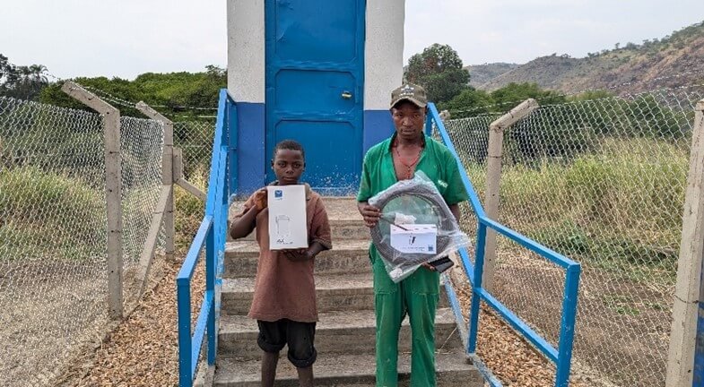
Communities in Kiiha catchment supported with an apiary as an alternative income-generating activity (funded by GOU